June 20, 2026 · 4 min read
Mount Pinatubo's crater lake, with its mesmerizing turquoise waters, stands as a powerful testament to nature's raw force and subsequent rebirth. The 1991 eruption, one of the 20th century's largest, reshaped an entire region, creating a landscape that is both desolate and breathtakingly beautiful.
But what is it like to hike to the summit of Mount Pinatubo today, beyond the iconic viewpoint? The journey offers more than just stunning vistas; it's a deep dive into layers of geological history, indigenous resilience, and surprising natural artistry that most visitors overlook. These are the hidden wonders waiting to be discovered.

1. The Shifting Sands of Crow Valley
Crow Valley, Capas, Tarlac, Philippines
The dramatic canyons carved by Mount Pinatubo's lahars aren't just barren paths; they're dynamic geological canvases, constantly revealing and burying the mountain's history.
The journey to Pinatubo begins through Crow Valley, a vast expanse of lahar-sculpted landscape. These deep, multi-layered canyons tell a vivid story of the 1991 eruption's aftermath, where volcanic debris flowed like rivers, shaping an otherworldly terrain that continues to shift with every monsoon season, exposing new geological layers and re-carving the paths.
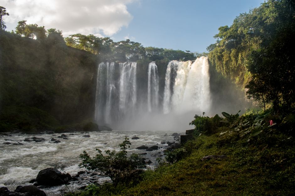
2. Miyamit Falls: A Pre-Eruption Echo
Botolan, Zambales, Philippines
Tucked away from the main trek, Miyamit Falls offers a rare glimpse of Pinatubo's ancient ecosystem, a pocket of life that survived the 1991 cataclysm.
While the crater lake dominates, Miyamit Falls represents enduring life. Its waters cascade over ancient rock formations, a stark contrast to the surrounding volcanic desert. These springs predate the eruption, offering a quiet, green sanctuary and a reminder of the lush landscape that once characterized the mountain's lower slopes before its explosive awakening.
3. Tracing Ancient Footsteps
Mount Pinatubo, Philippines
The very trails leading to Pinatubo's summit often follow routes used by the indigenous Aeta people for centuries, long before the volcano's modern fame.
Beyond the 4x4 track, the hiking path to the crater lake often overlays ancestral routes of the Aeta, the original inhabitants of the Pinatubo region. These communities possess deep traditional knowledge of the mountain, its hidden springs, and medicinal plants, reflecting a spiritual connection that predates any recorded geological event.
4. The Buried Farmlands
Capas, Tarlac, Philippines
The vast, desolate sand plains surrounding Pinatubo weren't always barren; they were once fertile agricultural land, instantly entombed by the 1991 eruption.
The extensive lahar fields, often likened to a desert, are a poignant testament to the 1991 eruption's power. What now appears as a desolate expanse was, just decades ago, a vibrant agricultural heartland, sustaining numerous communities. The land lies buried beneath meters of volcanic debris, a silent monument to the immediate and dramatic transformation of the landscape.

5. Ephemeral Art in Volcanic Ash
Mount Pinatubo Lahar Plains, Philippines
After heavy rains, the volcanic sands near Pinatubo's base transform into intricate, ephemeral relief sculptures, carved by water and wind.
The fine volcanic ash and sand covering the plains become an artist's canvas after rainfall. Water carves delicate, temporary patterns and miniature canyons, revealing subtle stratifications and mineral colors. These fleeting geological artworks, constantly changing with the elements, highlight the dynamic nature of the post-eruption landscape, offering unique visual discoveries.
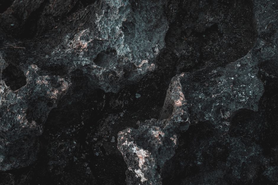
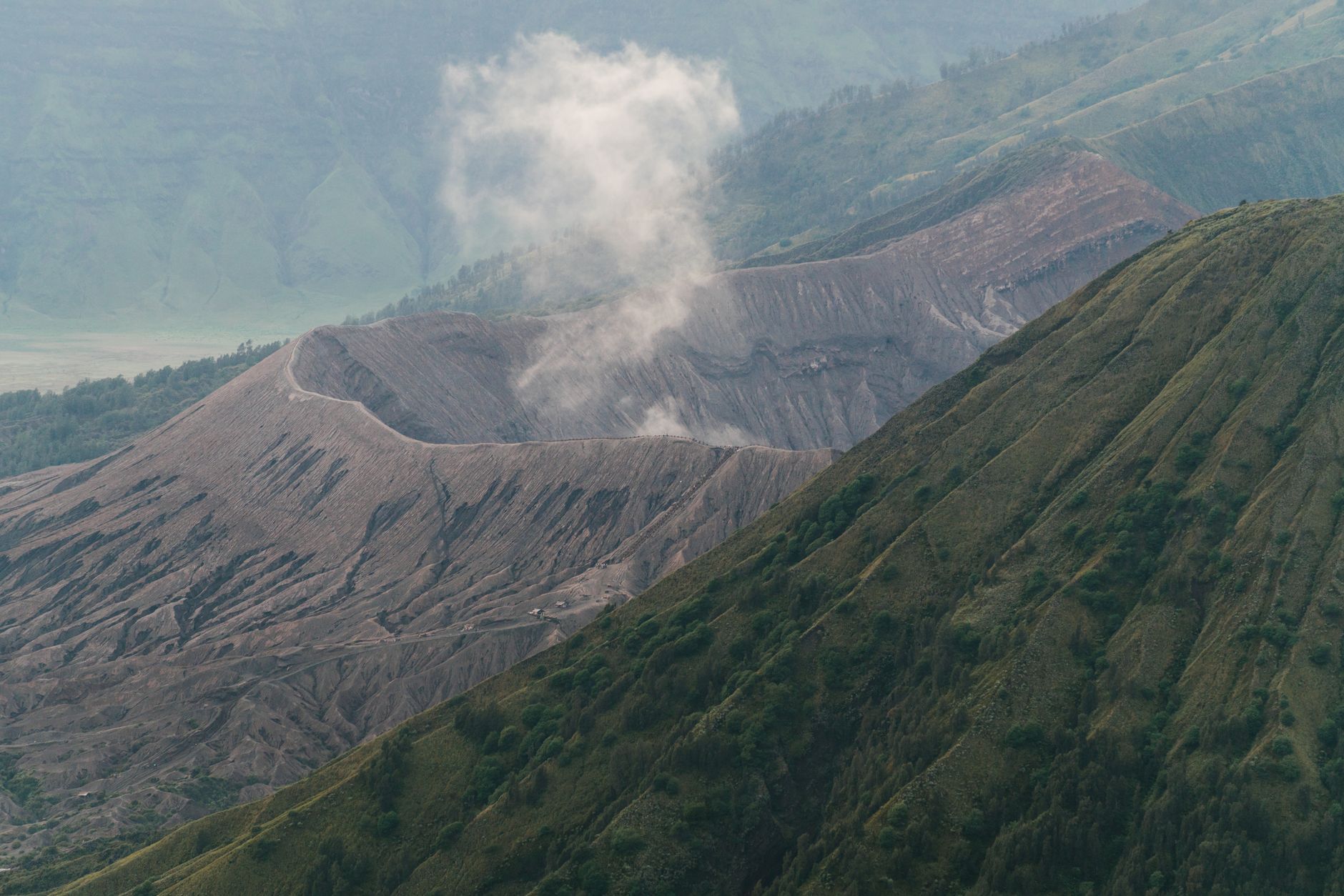
6. Exposed Ancient Volcanic Cores
Pinatubo Crater Ridge, Philippines
Look closely at the crater's edges, and you might spot sections of much older rock, revealing Pinatubo's multi-million-year history long before its 1991 awakening.
While the crater lake and immediate surroundings are products of the 1991 eruption, some of the rugged ridges framing the caldera expose layers of older volcanic rock. These ancient intrusions and uplifted strata tell a geological tale spanning millions of years, hinting at Pinatubo's prior cycles of activity and its deep origins as a complex stratovolcano.
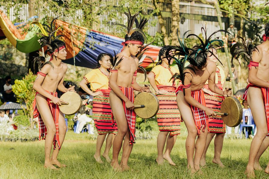
7. Resilient Spirits of Sapang Uwak
Sapang Uwak, Porac, Pampanga, Philippines
The Aeta community of Sapang Uwak, displaced by the 1991 eruption, has not only rebuilt their lives but also preserved their unique indigenous culture amidst the changing landscape.
Forced to relocate after the eruption, the Aeta people of Sapang Uwak exemplify remarkable resilience. Here, traditional practices like foraging and weaving coexist with modern adaptations. Their deep spiritual connection to the land and their distinct language and customs continue to thrive, offering a powerful human story of survival and cultural preservation in the shadow of the volcano.
8. The Living Sands of Pasig-Potrero
Pasig-Potrero River, Pampanga, Philippines
The sand-choked Pasig-Potrero River, devastated by lahars, still teems with unique adapted life, a testament to nature's ability to reclaim even the most altered landscapes.
Once a vital waterway, the Pasig-Potrero River was engulfed by massive lahars, transforming it into a wide, sandy expanse. Today, while much of it remains altered, life has begun to return in unexpected ways. Specialized plants and insects have adapted to the volatile environment, and the river still acts as a conduit for sediment, constantly reshaping its banks and demonstrating nature's persistent reclamation.
Frequently asked questions
How long does it take to hike Mount Pinatubo?
The full trip typically takes a full day. This includes a 1-2 hour 4x4 ride each way to the jump-off point, followed by a 1.5 to 2.5-hour hike to the crater lake, depending on your pace and the trail conditions.
Is the Mount Pinatubo hike difficult?
It's generally considered a moderate hike. The terrain is mostly flat or gently sloping sand and rocky paths, but there are several river crossings and a final ascent with steps to the crater rim. Good physical condition is recommended, but no advanced mountaineering skills are required.
What should I bring for the Pinatubo hike?
Essential items include plenty of water, snacks, sun protection (hat, sunscreen), and comfortable trekking shoes or sandals (expect wet feet from river crossings). A light jacket, a camera, and a small backpack are also highly recommended. Dress in quick-drying clothing.
How can AllTours.ai enhance my Mount Pinatubo experience?
AllTours.ai transforms your hike into an immersive journey of discovery. Simply point your phone camera at a landmark or landscape along the Pinatubo trail, and the app will instantly narrate its history, geological formation, and cultural significance in your preferred language, revealing stories you might otherwise miss.
Photography via Pexels. AllTours.ai is an AI audio tour guide — point your camera at any landscape and hear its story.