June 21, 2026 · 4 min read
Mount Pinatubo, once a symbol of immense destructive power, has quietly transformed into one of the Philippines' most breathtaking natural wonders. Its infamous 1991 eruption reshaped landscapes and lives, but today, its caldera cradles a mesmerizing turquoise lake that draws adventurers from around the globe. Yet, the true story of Pinatubo extends far beyond that iconic view.
Hiking to the summit of Mount Pinatubo today is more than just reaching a viewpoint; it's a journey through a living testament to geological forces and human resilience. While the crater lake is undeniably stunning, the surrounding areas hold a treasure trove of lesser-known spots, each with a surprising tale of history, geology, or culture waiting to be uncovered. These are the places that truly reveal the volcano's enduring legacy.
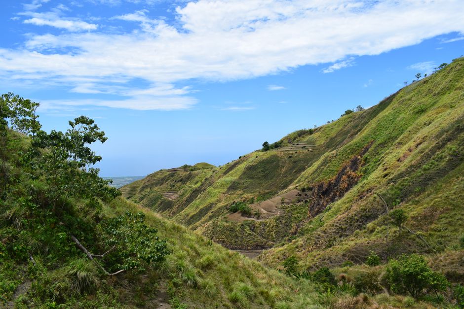
1. The 'Grand Canyon' of Crow Valley
Crow Valley, Capas, Tarlac, Philippines
Just beyond the familiar jump-off point, the erosion from Pinatubo's 1991 eruption carved a landscape so vast and intricate, it's been dubbed the 'Grand Canyon of the Philippines.'
The Crow Valley used to be a wide, flat riverbed. After the 1991 eruption, massive lahar flows, a destructive mixture of volcanic ash and water, sculpted dramatic canyons hundreds of feet deep. Walking through these towering walls of solidified ash reveals the sheer power of the volcano, a stark reminder of the earth's raw forces at work. The scale here is truly humbling, offering a unique perspective on post-volcanic landscapes.

2. The Aeta Ancestral Domain of Sitio Haduan
Sitio Haduan, Mabalacat, Pampanga, Philippines
The Aeta people, indigenous to Pinatubo's slopes, were displaced by the eruption but have since returned, their ancient connection to the land enduring through generations of volcanic cycles.
Sitio Haduan is one of several Aeta communities impacted by the 1991 eruption. While many were relocated, some Aeta families eventually returned to their ancestral lands, demonstrating remarkable resilience. Their deep knowledge of the flora, fauna, and even the volcano's temperament predates any written history, offering insights into survival and adaptation that are rarely heard by casual hikers. Their stories of the 'old Pinatubo' are invaluable.
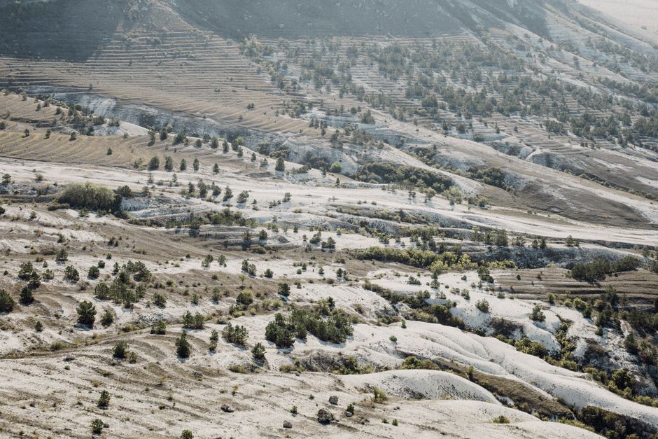
3. The Moonscape of Lahar Fields
Near Capas Jump-off Point, Tarlac, Philippines
The vast plains leading to Pinatubo's crater are not barren wasteland, but a dynamic 'moonscape' of solidified lahar, revealing an otherworldly beauty sculpted by fire and water.
As your 4x4 traverses towards the trek's starting point, you pass through immense fields of lahar, which solidified into bizarre, undulating formations. This landscape, often called a 'moonscape,' is the result of pyroclastic flows from the eruption that later mixed with rain to form cement-like rivers of ash and debris. The sheer scale and alien textures here feel like stepping onto another planet, a testament to the volcano's transformative power.
4. The Bucao River Delta's Expanding Coastline
San Narciso, Zambales, Philippines
Far from the crater, the Bucao River delta tells a story of geological creation, where Pinatubo's eruption added new land to the Philippine coastline.
The eruption of Mount Pinatubo unleashed colossal amounts of ash and debris. Over the years, much of this material was carried by rivers like the Bucao towards the sea. The delta at the mouth of the Bucao River expanded significantly, extending the coastline and creating new land. This ongoing geological process demonstrates how a single event can dramatically alter geography hundreds of kilometers away, a subtle but profound legacy of the eruption.
5. Puning Hot Springs: A Volcanic Phoenix
Sitio Puning, Porac, Pampanga, Philippines
These natural hot springs and sand baths are a direct, therapeutic byproduct of Pinatubo's lingering volcanic heat, discovered and maintained by the local Aeta community.
Tucked away on the lower slopes, Puning Hot Springs weren't there before the eruption. They emerged as a result of the volcano's geothermal activity, offering unique hot sand and mud baths believed to have healing properties. The Aeta people, who operate and maintain this site, consider it a sacred place, integrating their traditional knowledge with the geological gift. It's a surprising oasis of warmth and wellness born from destruction.

6. The 'White Ash Desert' of Pasbul Trail
Pasbul Trail, Porac, Pampanga, Philippines
While most hikers use the Capas route, the lesser-known Pasbul Trail offers a more rugged journey through vast, often untouched fields of fine white volcanic ash.
The Pasbul Trail, originating from Porac, Pampanga, presents a different and more challenging approach to Pinatubo. This route is characterized by extensive stretches of fine, almost white volcanic ash, creating an environment that feels like a vast desert. Fewer visitors mean a more solitary and immersive experience, where the silence is broken only by the wind and the crunch of ash underfoot, highlighting the raw, untamed beauty of the post-eruption landscape.
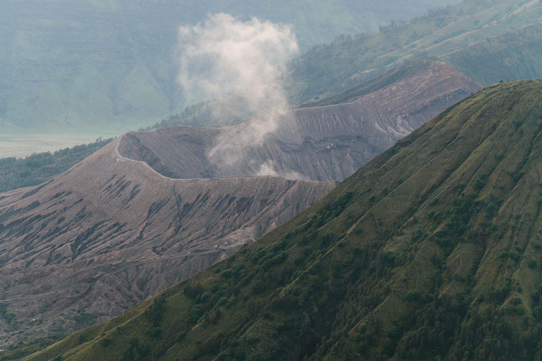
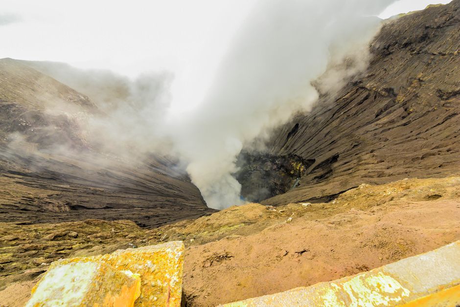
7. Lake Pinatubo's Shifting Shores
Mount Pinatubo Crater Lake, Zambales/Tarlac/Pampanga, Philippines
The stunning turquoise crater lake is not static; its water levels constantly shift, revealing or submerging parts of the caldera rim and changing access points.
While the vibrant blue-green water of Lake Pinatubo is the ultimate reward, few realize its dynamic nature. The lake's water level fluctuates significantly depending on rainfall and drainage, sometimes revealing more of the steep caldera walls, other times making direct shore access challenging. This constant flux means that each visit can offer a slightly different perspective of the caldera's geology, a living, breathing testament to the volcano's continued influence.
Frequently asked questions
How long does the Mount Pinatubo hike take?
The entire trip, including the 4x4 ride across the lahar fields and the trek to the crater, typically takes a full day. The actual hike from the jump-off point to the crater lake and back is usually 2-3 hours each way, depending on your pace and the specific trail conditions.
What should I bring for the Mount Pinatubo hike?
Essential items include plenty of water, snacks, sunscreen, a hat, sunglasses, comfortable trekking shoes or sandals (expect river crossings), a light jacket for cooler mornings, and a waterproof bag for electronics. Don't forget your camera for the stunning views!
How can AllTours.ai enhance my Mount Pinatubo experience?
AllTours.ai transforms your hike into an interactive journey. Simply point your phone camera at a lahar canyon, a unique rock formation, or even a distant peak, and the app will instantly narrate its history, geological formation, and cultural significance in your preferred language, revealing stories you might otherwise miss.
Self-guided audio tours
Walk these places stop by stop — free five-stop story tours you can take at your own pace:
Photography via Pexels. AllTours.ai is an AI audio tour guide — point your camera at any landscape and hear its story.