June 21, 2026 · 4 min read
Mount Pinatubo, once a symbol of cataclysmic power, now beckons adventurers with its serene crater lake and surreal landscapes. The 1991 eruption reshaped the Luzon island, creating a moonscape of ash and lahar that has since transformed into a unique natural wonder. While the iconic turquoise lake is the ultimate reward, the journey itself is rich with untold stories.
Beyond the well-trodden paths to the main viewpoint, Pinatubo reveals lesser-known facets of its history, geology, and the remarkable resilience of life and culture. Prepare to explore hidden geothermal secrets, ancient riverbeds turned into highways of ash, and the surprising tenacity of nature reclaiming a land reborn from fire.
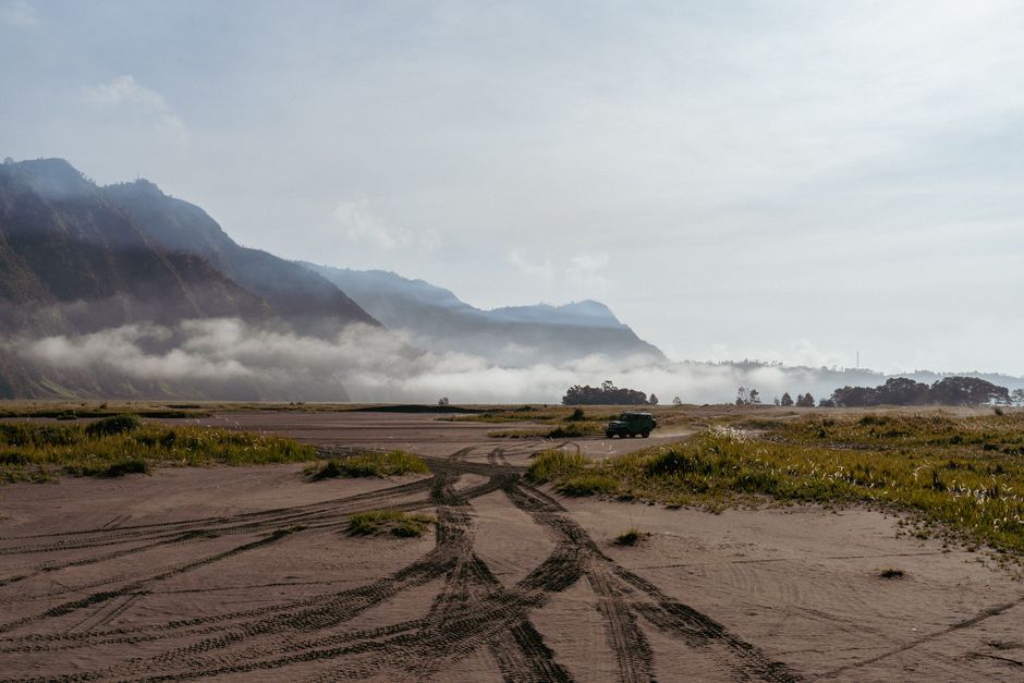
1. The Shifting Sands of the 4x4 Trail
Capas, Tarlac, Philippines
Your journey begins on a highway of ash, constantly reshaped by nature's raw power.
Before any foot touches the hiking trail, adventurers traverse a vast expanse of lahar fields via 4x4. These seemingly desolate plains are ancient riverbeds choked with volcanic debris, where skilled drivers navigate shifting sands and shallow streams, offering a visceral introduction to Pinatubo's immense geological footprint, a landscape that changes subtly with every monsoon season.
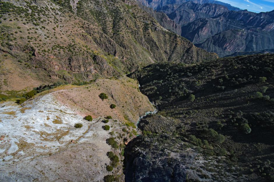
2. Canyons Carved by Liquid Stone
Pinatubo Trek Canyons, Philippines
Walk through valleys dramatically sculpted by solidified mudflows and monsoon rains.
The hiking path descends into surreal, intricate canyons, a direct result of the 1991 eruption's colossal lahar flows. As these mudflows solidified and were subsequently eroded by heavy rainfall over decades, they carved deep channels. This creates a unique, otherworldly landscape where towering walls of compressed ash reveal the raw power of geological forces.

3. Echoes of Ancestral Resilience
Pinatubo Ancestral Domain, Philippines
The land tells a story of indigenous communities who faced catastrophe and returned to their sacred mountain.
The slopes of Pinatubo are the ancestral home of the Aeta people, who were displaced by the 1991 eruption. Their deep spiritual connection to the mountain endures, and despite the devastation, many have returned, adapting their traditional way of life amidst the volcano's rebirth. Their presence is a testament to profound resilience and cultural heritage, woven into the very fabric of the landscape.
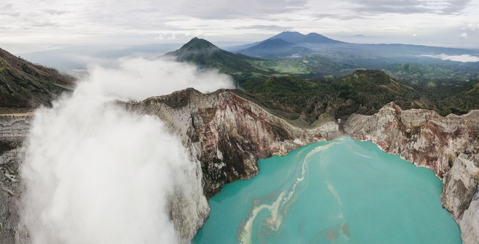
4. The Lake's Ever-Changing Palette
Mount Pinatubo Crater Lake, Philippines
The iconic turquoise lake is not static; its colors shift, revealing the volcano's subtle, ongoing activity.
While famous for its stunning turquoise, Pinatubo's crater lake displays a dynamic range of colors. Depending on mineral content, sunlight, and even microscopic algae blooms, it can appear emerald green, deep sapphire, or occasionally, a milky grey. This vibrant variability is a living indicator of the complex geological and biological processes within the caldera, a constant work in progress.
5. Hidden Warmth in the Flow
Pinatubo River Crossings, Philippines
As you cross the streams, feel the subtle warmth in the water – a whisper from the volcano's depths.
The numerous river crossings along the trek offer a surprising geological detail: the water temperature can vary. In certain spots, you might feel a distinct warmth beneath your feet, a direct result of geothermal activity lingering beneath the ash and rock. These warm currents are a constant, subtle reminder of the colossal heat still deep within Pinatubo, shaping the very water you wade through.

6. Life's Tenacious Return
Pinatubo Slopes, Philippines
Amidst the stark volcanic landscape, discover surprising pockets of life reclaiming the ash-covered slopes.
The journey reveals nature's incredible resilience. What was once barren ash is now slowly being colonized by pioneer species – hardy grasses, ferns, and small shrubs. These tenacious plants represent the first wave of ecological succession, gradually transforming the desolate moonscape back into a vibrant ecosystem, year by year, a silent testament to life's unwavering persistence.
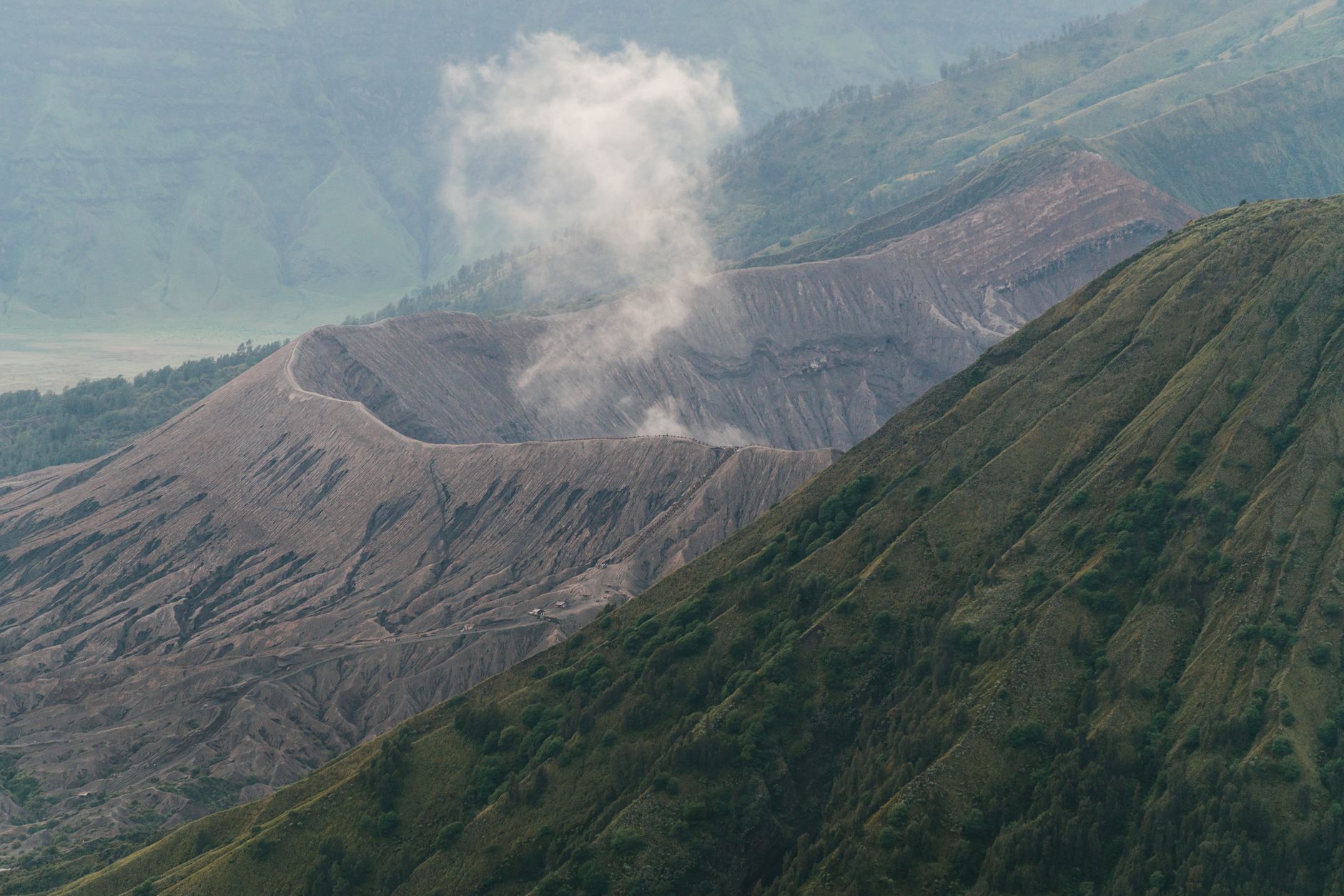
7. The Climb to the Real Summit
Pinatubo Crater Rim Trail, Philippines
The final ascent involves navigating several 'false summits,' each revealing a new, breathtaking perspective.
After traversing the flat lahar plains and canyons, the path turns steeply upwards towards the crater rim. This final segment often presents several 'false summits,' each one teasing with a view before revealing another incline. With every step, the expansive landscape unfurls below, culminating in the dramatic reveal of the stunning caldera lake from the highest point along the rim.
Frequently asked questions
Is Mount Pinatubo safe to hike today?
Yes, Mount Pinatubo is regularly monitored by PHIVOLCS, the Philippine Institute of Volcanology and Seismology. Tours are only permitted when conditions are deemed safe. Always go with a registered tour operator and follow their guidance, as volcanic activity can change.
How long does it take to hike Mount Pinatubo?
The entire trip, including the 4x4 ride and the hike, typically takes a full day, starting early in the morning. The 4x4 ride is about 1.5-2 hours each way, and the hike itself is usually 1.5-2 hours each way, depending on your pace and the specific trail conditions.
What should I bring for the Pinatubo trek?
Essential items include sturdy trekking sandals or closed-toe shoes suitable for varied terrain and water crossings, a hat, sunglasses, ample sunscreen, plenty of water (at least 2-3 liters), snacks, and a light rain jacket, especially during monsoon season. A small first-aid kit and a dry bag for electronics are also advisable.
How does the AllTours app enhance a Pinatubo hike?
The AllTours.ai app transforms your Pinatubo hike into an immersive journey. Simply point your phone camera at the crater lake, the vast lahar fields, the unique canyon formations, or even the resilient pioneer plants, and the app instantly narrates their history, geology, and cultural significance in your preferred language, offering insights far beyond what a traditional guide can provide.
Photography via Pexels. AllTours.ai is an AI audio tour guide — point your camera at any landscape and hear its story.